Sat, 17 Apr 2021, 01:24
01:24 AM | BY: EARTHQUAKEMONITOR
5.5 quake 17 Apr 8:04 am (GMT +7)
The quake hit at an intermediate depth of 88 km beneath the epicenter near Banda Aceh, Kota Banda Aceh, Aceh, Indonesia, in the morning on Saturday 17 April 2021 at 8:04 am local time. The exact magnitude, epicenter, and depth of the quake might be revised within the next few hours or minutes as seismologists review data and refine their calculations, or as other agencies issue their report.
A second report was later issued by the European-Mediterranean Seismological Centre (EMSC), which listed it as a magnitude 5.1 earthquake. A third agency, the German Research Centre for Geosciences (GFZ), reported the same quake at magnitude 4.7.
Based on the preliminary seismic data, the quake should not have caused any significant damage, but was probably felt by many people as light vibration in the area of the epicenter.
Weak shaking might have been felt in Banda Aceh (pop. 250,800) located 61 km from the epicenter, Sigli (pop. 17,500) 85 km away, Sabang (pop. 24,500) 100 km away, Reuleuet (pop. 40,400) 112 km away, and Meulaboh (pop. 35,100) 131 km away.
VolcanoDiscovery will automatically update magnitude and depth if these change and follow up if other significant news about the quake become available. If you’re in the area, please send us your experience through our reporting mechanism, either online or via our mobile app. This will help us provide more first-hand updates to anyone around the globe who wants to know more about this quake.
If you felt it, report it through our site or app right now!
Earthquake data:
I felt this quake
Date & time: 17 Apr 8:04 am (GMT +7) local time (17 Apr 2021 01:04 GMT)
Magnitude: 5.5
Depth: 88.0 km
Epicenter latitude / longitude: 4.99°N / 95.3°E
Primary data source: BMKG
Previous news
Sat, 17 Apr 2021, 01:21
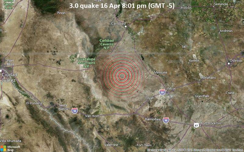
The United States Geological Survey reported a magnitude 3.0 quake in the United States near Toyah, Reeves County, Texas, only 16 minutes ago. The earthquake hit in the evening on Friday 16 April 2021 at 8:01 pm local time at a very shallow depth of 4.8 miles. The exact magnitude, epicenter, and depth of the quake might be revised within the next few hours or minutes as seismologists review data and refine their calculations, or as other agencies issue their report. ... read all
Sat, 17 Apr 2021, 01:09
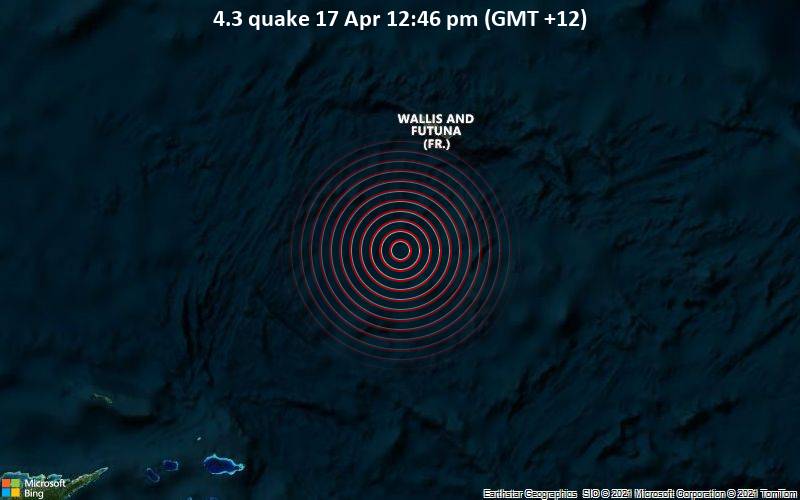
A magnitude 4.3 earthquake near Alo, Wallis & Futuna, was reported only 23 minutes ago by the European-Mediterranean Seismological Centre (EMSC), considered one of the key international agencies that monitor seismic activity worldwide. The earthquake occurred at a great depth of 400 km beneath the epicenter around noon on Saturday 17 April 2021 at 12:46 pm local time. The exact magnitude, epicenter, and depth of the quake might be revised within the next few hours or minutes as seismologists review data and refine their calculations, or as other agencies issue their report. ... read all
Sat, 17 Apr 2021, 00:24
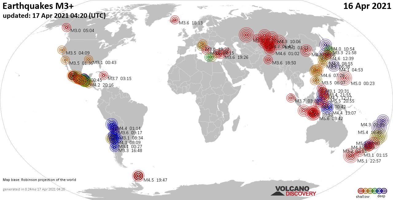
Summary: 10 quakes 5.0+, 30 quakes 4.0+, 103 quakes 3.0+, 215 quakes 2.0+ (358 total) ... read all
Fri, 16 Apr 2021, 23:50
Fri, 16 Apr 2021, 23:17

Just 6 minutes ago, a 5.1-magnitude earthquake struck near Te Anau, Southland District, Southland, New Zealand. The tremor was recorded in the morning on Saturday 17 April 2021 at 10:57 am local time, at a very shallow depth of 9.1 km below the surface. ... read all
https://news.google.com/__i/rss/rd/articles/CBMiiwFodHRwczovL3d3dy52b2xjYW5vZGlzY292ZXJ5LmNvbS9lYXJ0aHF1YWtlL25ld3MvMTI3NTUzL01hZ25pdHVkZS01NS1lYXJ0aHF1YWtlLXN0cmlrZXMtbmVhci1CYW5kYS1BY2VoLUtvdGEtQmFuZGEtQWNlaC1BY2VoLUluZG9uZXNpYS5odG1s0gEA?oc=5
2021-04-17 01:25:38Z


Tidak ada komentar:
Posting Komentar